
The quickest way into the question of how many islands Japan has is to set the old and new counting methods side by side, then look at the distribution on a tile map of the 47 prefectures. The national total alone does not show regional differences, so the list and the map appear together here.
Japan has 14,125 islands, according to the latest figure published by the Geospatial Information Authority of Japan (GSI) on February 28, 2023. The figure in use before that, 6,852 islands, was published by the Japan Coast Guard in 1987. The new count is about 2.1 times the old one, an increase of +7,273 islands.
The core counting rules are nearly the same at both points: naturally formed islands with a perimeter of 0.1 km or more, with artificial islands and islands in inland waters excluded. According to GSI, the increase does not reflect new islands but more detailed mapping on the Digital Japan Basic Map. Measured again under the same rules, landforms once treated as a single island were recorded as several.
This article uses GSI’s Material 3, a list of island counts for the whole country and for each prefecture, as its primary data. It sets out six charts: the old and new counting methods, a prefecture ranking, a 47-prefecture tile map, a histogram by class, a breakdown of the prefectures with no islands, and a complete table of all 47.
Some features of the distribution are hard to see in the national total alone. Nine of the 47 prefectures record zero islands, and one of them, Osaka Prefecture, records zero even though it faces the sea. The charts below place these points side by side so that the contrasts can be read directly from the data.
Japan’s official island count comes from the Geospatial Information Authority of Japan (GSI), the national mapping agency. It counts naturally formed land with a perimeter of 0.1 km or more, excluding artificial islands and islands in lakes and rivers. The count is taken from the Digital Japan Basic Map, the agency’s national digital base map. Prefectures are Japan’s 47 top-level administrative regions, from Hokkaido in the north to Okinawa in the south. The earlier figure of 6,852 was published by the Japan Coast Guard in 1987.
How many islands does Japan have, and how are they spread across the 47 prefectures?
14,125, confirmed in a 2023 recount. Nagasaki leads with 1,479, the top three hold about 30%, and 9 prefectures have none.
This article was researched and edited by Kaede. Figures are current as of the time of writing. Statistics, rules and services are subject to change, so please check the official sources for the latest information.
- Japan Has 14,125 Islands: What Changed in the 2023 Recount
- Islands by Prefecture: Nagasaki (1,479) and Hokkaido (1,473) Nearly Tied
- A 47-Prefecture Map of Where Japan’s Islands Are
- How the 47 Prefectures Spread Across Island Classes: Mean, Median and Mode
- The 9 Prefectures with No Islands: 8 Landlocked, and Osaka on the Coast
- Complete List: Island Counts for All 47 Prefectures
- Kaede’s Summary: Three Observations from the Distribution of 14,125 Islands
- Frequently Asked Questions
- 🔍 About the Fact-Check for This Article
Japan Has 14,125 Islands: What Changed in the 2023 Recount
The total of 14,125 reads more clearly next to the 1987 figure of 6,852, with a check on whether the counting rules stayed the same. With the old and new methods on one chart, the change looks less like new islands appearing and more like the map becoming more detailed.
* Compiled and edited by the Japan in Data editorial team based on official government statistics.
GSI published the figure of 14,125 islands on February 28, 2023. Until then, the most widely used figure was 6,852, given by the Japan Coast Guard in 1987 in its report Current State of Maritime Safety. The counting rules at both points are nearly the same: naturally formed islands with a perimeter of 0.1 km or more, excluding artificial islands and islands in lakes and rivers.
The base map is what differs. The old figure relied on nautical charts and checks in the field, while the new one draws on the Digital Japan Basic Map and on data from laws and regulations. The 2023 count is also set up so that islands defined in law are not counted twice.
The increase of +7,273 islands does not mean that new land physically appeared. According to GSI, the Digital Japan Basic Map draws landforms in finer detail, so areas once treated as a single island are now drawn as several. GSI also reported that the map shows 120,729 land features in total, of which 14,125 meet the counting rules. The same rules, applied to a more detailed map, produced a different number.
Islands by Prefecture: Nagasaki (1,479) and Hokkaido (1,473) Nearly Tied
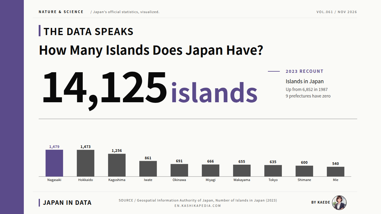
Sorted from the top as horizontal bars, the prefectural counts show a clear step between the top three and everything below them. A dotted line at 1,000 islands separates the prefectures above it from those below at a glance.
* Compiled and edited by the Japan in Data editorial team based on official government statistics.
Nagasaki Prefecture ranks first with 1,479 islands. Its waters in the East China Sea and the Genkai Sea hold island groups such as the Goto Islands, Tsushima, Iki and the Hirado Islands. Hokkaido is second with 1,473, just 6 fewer. Its count includes outlying islands such as Rishiri and Rebun, plus small islands along the Sea of Okhotsk coast and around the Soya Strait.
Kagoshima Prefecture is third with 1,256, centered on the Amami Islands, the Tokara Islands and the wider Satsunan Islands. Each of the three holds more than 1,000 islands. Together the top three hold 4,208 islands, about 30% of the national total of 14,125.
Below them come Iwate (861), Okinawa (691), Miyagi (666), Wakayama (655), Tokyo (635), Shimane (600) and Mie (540). Each has a distinctive coastline or island group: the ria coast of the Sanriku region in Iwate and Miyagi, the Nansei Islands in Okinawa, the Kii Channel in Wakayama, the Izu and Ogasawara Islands in Tokyo, the Oki Islands in Shimane and the indented Kumano-nada coast in Mie.
Read by class, the ranking forms geographic groups. The three prefectures above 1,000 islands each hold long chains of outlying islands. The seven in the 500 to 999 range each have an intricate coastline or a cluster of island groups, from the Tohoku coast in the northeast to the waters south of Tokyo.
A 47-Prefecture Map of Where Japan’s Islands Are
A ranking shows the top and the bottom; a map shows the regional clusters. With the 47 prefectures shaded in five classes by island count, the color gathers in western Kyushu, along the ria coast of Tohoku and in the waters south of Tokyo.
* Compiled and edited by the Japan in Data editorial team based on official government statistics.
On the tile map, the darker tiles (more islands) form a few geographic clusters. The darkest purple, 1,000 islands or more, covers three prefectures: Nagasaki at the western edge of Kyushu, Hokkaido in the north, and Kagoshima at the southern tip of Kyushu. All three hold chains of outlying islands in waters away from Honshu, the largest of the main islands.
The medium-dark purple, 500 to 999 islands, covers Iwate and Miyagi on the Tohoku ria coast, Wakayama on the Kii Peninsula, Tokyo (including the Izu and Ogasawara Islands), Shimane on the Sea of Japan side of the Chugoku region, Mie on the Kumano-nada coast, and Okinawa in the Nansei Islands. Each of these prefectures has a complex coastline.
The paler tiles (fewer islands) gather in inland Kanto, the mountains of central Japan, the basins of the Kinki region and the inland side of northern Tohoku. The palest, zero islands, covers 9 prefectures. Eight are landlocked, from Saitama Prefecture and its Kanto neighbors Tochigi and Gunma to Yamanashi, Nagano, Gifu, Shiga and Nara. The ninth is Osaka, which faces the sea but has no naturally formed islands.
Read by color alone, the tile map shows a pattern that closely follows geography. The number of islands lines up with conditions such as the length and complexity of the coastline, the distance from the main islands and the depth of the surrounding sea. The shading makes this pattern visible without further calculation.
How the 47 Prefectures Spread Across Island Classes: Mean, Median and Mode
Grouping the prefectures into five classes by island count gives a histogram of how many prefectures fall into each class. Setting the mean, the median and the most common class side by side shows the shape of the distribution across all 47.
* Compiled and edited by the Japan in Data editorial team based on official government statistics.
Split into five classes, the largest group is 100 to 499 islands, with 20 prefectures. Next come zero islands with 9 prefectures, 1 to 99 islands with 8 and 500 to 999 islands with 7. The top class, 1,000 islands or more, holds 3. The shape is a peak in the middle range (100 to 499 islands) with small bulges at both ends, zero and 1,000 or more.
The mean number of islands per prefecture is about 300.6 and the median is 180. The mean sits above the median: the three top prefectures, Nagasaki, Hokkaido and Kagoshima, hold very large counts that raise the average. Half of the 47 prefectures have about 180 islands or fewer, and the most common class is 100 to 499 islands. The mean is about 300 islands, yet half of all prefectures have 180 or fewer, a gap that reflects the weight of the top three.
The 9 Prefectures with No Islands: 8 Landlocked, and Osaka on the Coast
Nine prefectures record no islands. Eight are landlocked, but one is not: Osaka faces the sea and still counts zero naturally formed islands. Set side by side, the eight landlocked prefectures and Osaka show that “zero islands” carries two different meanings.
* Compiled and edited by the Japan in Data editorial team based on official government statistics.
Of the 9 prefectures with zero islands, 8 are landlocked: Tochigi, Gunma, Saitama, Yamanashi, Nagano, Gifu, Shiga and Nara. With no coastline, they have no sea islands to count, and the result is zero. All sit in the interior of Honshu: Tochigi, Gunma and Saitama in the north of the Kanto region, Yamanashi, Nagano and Gifu in the central mountains, and Shiga and Nara in the Kinki basins.
The remaining one is Osaka. Osaka faces Osaka Bay and the Kii Channel, yet GSI’s count of naturally formed islands there is zero. The relevant rule is the exclusion of artificial islands. The Osaka Bay shore consists of shallow water and large reclaimed areas, and major artificial islands such as Kansai International Airport and Yumeshima fall outside the count.
No naturally formed island with a perimeter of 0.1 km or more is recorded at the mouth of the Yodo River or inside Osaka Bay. Osaka is the only prefecture in Japan that faces the sea and records zero islands, which sets it apart as the one exception among the 9.
Complete List: Island Counts for All 47 Prefectures
This is the complete table of island counts for the 47 prefectures, in prefecture-code order. A figure in the “Shared” column means the prefecture has islands that straddle its border with a neighbor. With the breakdown of the 14,125 total on one chart, the full range of regional differences is visible at once.
* Compiled and edited by the Japan in Data editorial team based on official government statistics.
The table lists the 47 prefectures in prefecture-code order, from Hokkaido to Okinawa, with each prefecture’s island count and a “Shared” figure for islands that straddle two neighboring prefectures. Ten prefectures have shared islands: Fukui, Kyoto, Hyogo, Okayama, Hiroshima, Yamaguchi, Tokushima, Kagawa, Ehime and Kochi, with 1 to 3 each. Okayama has 3, Hiroshima and Kagawa 2 each, and the rest 1 each.
The prefectural figures and the national total of 14,125 relate in a specific way. Each prefecture counts the islands it treats as its own, including its part of the four main islands of Hokkaido, Honshu, Shikoku and Kyushu, and islands that straddle two prefectures are counted in both. The national total of 14,125 is the figure after these overlaps are resolved. The prefectural figures show the scale of each region’s islands, while the national total is the count without duplicates.
Kaede’s Summary: Three Observations from the Distribution of 14,125 Islands
Six charts have covered the old and new counting methods, the top ranking, the tile map, the class distribution, the prefectures with no islands and the complete table. Laid over one another, they reduce to three observations.
On the question of how many islands Japan has, the six charts in this article show three structures behind the single figure of 14,125: continuity between the old and new counting rules, concentration in the top three prefectures, and a contrast with the landlocked prefectures. The summary below sets out these features of the distribution as observations, without ranking any figure as better or worse.
Read together, the three observations present the figure of 14,125 as the combined result of three elements: the timing of the recount, the complexity of the terrain and geographic position. How many islands each prefecture has, and which prefectures have none, can be read as the meeting point of geography and counting rules. The answer to how many islands Japan has depends on the base map and on how the rules are set, and that observation describes the current picture more fully than any single number.
Frequently Asked Questions
An island count is read alongside three points: when the figure was published, which counting rules apply, and whether the main islands are included. The same number can tell a different story when any one of these three changes.
Q1. Did Japan’s island count more than double because new islands formed?
No. No new islands physically formed. According to GSI, the increase of +7,273, from 6,852 in 1987 to 14,125 in 2023, came with a switch in base map from paper nautical charts to the Digital Japan Basic Map, which draws terrain in more detail. The counting rules (naturally formed islands with a perimeter of 0.1 km or more, excluding artificial and inland-water islands) are nearly the same at both points. Areas once treated as one island are now drawn as several: the map became more detailed, rather than the islands multiplying.
Q2. Are the Northern Territories included in the count?
Yes. GSI’s 2023 figure of 14,125 counts the Northern Territories, including Etorofu, Kunashiri, Shikotan and the Habomai Islands, as Japanese territory. Hokkaido’s figure of 1,473 includes these islands as well as the main island of Hokkaido, outlying islands such as Rishiri and Rebun, and small islands along the Sea of Okhotsk coast and around the Soya Strait. The figure counts islands drawn on the map as Japanese territory; actual control of the islands and access to them are separate questions.
Q3. Are the Four Main Islands of Honshu, Hokkaido, Shikoku and Kyushu Counted as Islands?
Yes. Under the counting rules (naturally formed islands with a perimeter of 0.1 km or more), Honshu, Hokkaido, Shikoku and Kyushu are all counted. Prefectural figures such as Hokkaido’s 1,473 also include each prefecture’s part of the main islands as one island. The four main islands are a small part of the 14,125 total; the remaining 14,121 are outlying islands.
Okinawa Island, the largest island in Okinawa Prefecture, is counted in the same way, and the Nansei and Sakishima Islands are added to reach Okinawa’s total of 691. Figures quoted for Japan’s islands differ depending on whether they include the main islands or cover outlying islands only, so the scope of each figure is part of its meaning.
🔍 About the Fact-Check for This Article
Japan in Data fact-checks its articles. The evidence behind the fact-check for this page is set out below, with a link to the official source for each item.